
 |
| UK Travel Alert: Snow, Ice and Sub-Zero Temps Trigger Yellow Warning |
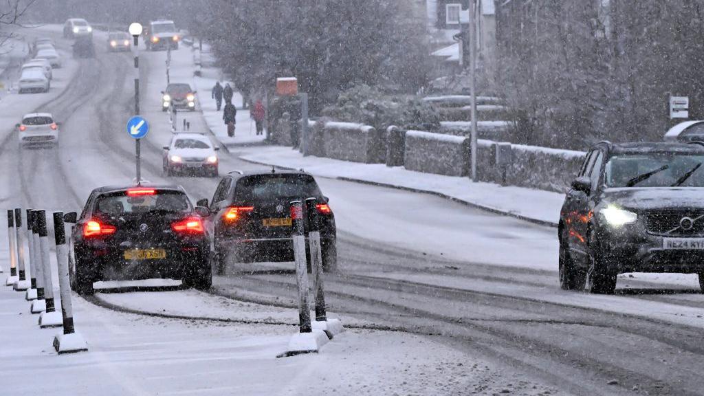
The Met Office has issued extensive yellow weather warnings for snow and ice across the United Kingdom as a strong blast of Arctic air moves southwards. Large parts of Scotland, northern England, Wales, and sections of the southwest are expected to face hazardous travel conditions, sub-zero temperatures, and periods of snowfall over the next 48 hours.
What Is Causing the Sudden Cold Snap?
Forecasters explain that the UK is currently positioned between milder Atlantic air and a powerful Arctic air mass descending from Iceland and northern Scandinavia. This meeting of air masses is creating the conditions for widespread wintry weather. Temperatures are expected to fall sharply during evening and overnight hours, causing ice to form quickly on untreated surfaces.
Meteorologists warn that temperatures in some rural and high-ground areas could drop as low as -10°C, increasing the risk of disruption and dangerous travel conditions.
Regions Covered by the Yellow Warning
Scotland
- Highlands, Grampian, Central Belt and surrounding areas
- Widespread snowfall of 2 to 5 cm expected
- Up to 15 to 20 cm possible on higher routes
- Significant ice on rural and untreated roads
Northern England
- Northumberland, County Durham, Yorkshire and the east coast
- Freezing rain and icy pavements likely during morning hours
- Hilly routes, including sections of the A66, A68 and A69, may become difficult to navigate
Wales
- North Wales and mid-Wales most affected
- Snow showers expected to drift inland during early morning
Southwest England
- Devon, Cornwall and parts of Somerset
- Unexpected wintry showers arriving from the Atlantic
- Possible local power interruptions due to freezing conditions
Expected Impacts for the Public
Transport Disruption
- Roads may become hazardous or impassable due to black ice
- Rail services may be delayed by frozen points and reduced visibility
- Bus services may be cancelled or diverted
- Airports could face delays caused by aircraft and runway de-icing operations
Health and Safety Concerns
- High risk of slips, trips and falls on icy surfaces
- Increased risk for elderly individuals and those with health conditions
- Greater vulnerability for rough sleepers and individuals without adequate heating
Infrastructure Issues
- Local power cuts may occur in rural regions
- Frozen pipes in older houses or buildings
- Delays in emergency response services due to poor road conditions
Weather Timeline
- Tonight: Temperatures fall rapidly below zero, creating widespread icy patches.
- Early Morning: Snow showers begin spreading across Scotland and northern England.
- Midday Tomorrow: Wintry showers extend into Wales and parts of southern England.
- Next 24 to 48 Hours: Persistent cold conditions with little chance for ice to thaw.
- End of the Week: Brief improvement expected before another cold front approaches.
How to Prepare and Stay Safe
- Check local weather and travel updates before leaving home
- Avoid unnecessary night-time travel
- Carry warm clothing, blankets and an ice scraper in your vehicle
- Use main roads wherever possible, as they are more likely to be gritted
- Wear footwear with strong grip to reduce slipping risks
- Check regularly on elderly neighbours or relatives
- Insulate pipes and taps in homes prone to freezing


Comments from Meteorologists
“Even small amounts of snow can lead to significant disruption when combined with freezing surfaces. The public should take extra caution on the roads and allow additional time for travel.”
Why This Weather Event Is Unusual
This cold front is notable for its speed and intensity. The southward reach of Arctic air is stronger than typical early-season cold events. Additionally, cold air passing over the North Sea is producing repeated bands of snow showers, similar to lake-effect snowfall patterns normally seen in North America.
How Long Will the Conditions Last?
The current forecast suggests that the freezing conditions will persist for at least three days. However, additional warnings may be issued depending on the movement of incoming weather systems. There may be a temporary improvement next week, but long-range models remain uncertain.
Frequently Asked Questions
Is the warning likely to be upgraded?
If snowfall intensifies or ice becomes more widespread, the Met Office may issue amber alerts for certain areas.
Could schools close?
Decisions will vary by local authority, but rural schools are the most likely to close if roads become unsafe.
Will public transport run normally?
Major delays are possible, especially during early morning and late evening hours.
Are more snow events expected this month?
Forecasters say further cold spells are likely, although exact timing is still uncertain.
This is a developing weather situation. Trendly-hub will continue to update this article as new information becomes available.


0 Comments